Friday, December 4, 2009

LYCHNIDOS


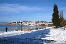
Ohrid is one of the rare cities in the Balkans, such as Thessalonika, Odessa and Dyrachion that had thrived uninterruptedly throughout the classical period. They survived the decline of the classical civilization and continued to live under their new names till the present time. The soil of this ancient city has seen numerous changes of civilization achievements followed by the inevitable falls and rises.

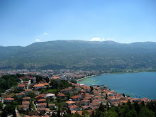
The contemporary city of Ohrid is a descendant of the antique town of Lychnidos. This was confirmed by several Byzantine sources in which it was written "the town is situated on a high hill near the large lake of Lychnidos, by which also the town was named Lychnis, previously known as Dyassarites". The existence of this town is also evident from numerous Roman documents. According to them, Lychnidos was located by the Via Egnatia, the oldest and most important Roman roadway in the Balkans. It started with two routes from Apollonia and Dyrachia and reached to Lychnidos through Candavian Mountains. Long before the Romans came into the region this route had been used as a communicational link between the coast and the internal parts of Illyria and Macedonia. Via Egnatia was the shortest route from Rome to the Eastern Empire.

.

The earliest inhabitants of the widest Lake Ohrid region that can be identified by name were Brigians and Enhelians. Brigians are the same as Phrygians. According to Herodotus, the Phrygians from Asia Minor used to live in Europe in the vicinity of the Macedonians and were called Brigians. After the Troy War they migrated to Asia Minor and changed their name into Phrygians.

Historically, Enhelians have been identified as Illyrians. However, it should be underlined that Herodotus, and some other historians, distinguish them from the Illyrians.

The origin of their name, Enhelians, derives from encheleus -"eel", "serpent", and connects this people with the Lychnidos Lake since it is rich in eel. During the Roman conquests, towards the end of III and the beginning of II century BC, Desaretes and the region Desaretia were mentioned, as well as the town of Lychnidos, Lychnidus and the region Lychnis. Desaretia was a vast region that stretched from Devol in the west to the Macedonian regions of Orestidia and Lynkestidia to the east. Lychnitidia, the region around Lake Ohrid, in the beginning emerged as a separate region outside the borders of Desaretia.

After the Roman conquest, the name Desarets appeared as the joint name of all tribes that lived in the mountainous region inside the area of Macedonia and South Illyria, stretching from the border with Epirus in the south to the Parthynes and Phenestes in the north and Lynkestes in the east.

LYCHNIDOS


Data on the political development of the Lychnidos region in the classical period is scarce and comes from preserved written documents. The first indicators of the political character of the region relate to the V century BC when, during the Pelophonnesus War in Greece on the northern border of Macedonia, a political community emerged. This community, named "Illyrians" by the classical writers, seriously threatened the safety of the Macedonian State at times.

It is said that the Illyrians held Macedonia enslaved before Philip II of Macedonia come power. With the arrival of Philip II the power shifted. This happened after the battle that most probably took place in Lynchestidis, today the Bitola Plain. The victorious party was the Macedonians. This battle was crucial for the further development of the relations between Illyria and Macedonia. It marked the end of the Illyrian domination over Macedonia. The Illyrians had to leave the region east of the northern shore of Lychnidos Lake.

In the year 335 BC, while Alexander III of Macedonia was on the river Danube, the Illyrian king Klit organized an insurrection against Macedonia. The sources do not mention the consequences of Alexander's victory over Klit. Several indirect data have shown that as a result Illyria was annexed to Macedonia, probably as a province under the administration of a strategist, as was the case with Trachia ever since the rule of Philip II.

During this period the region of Lychnidos was part of the Hellenic civilization and did not belong to the Latin speaking regions.

LYCHNIDOS


In the III century BC Rome expressed its aspiration towards the Balkans. Military actions begun and the Illyrian territories were used as starting bases in the war against the mighty Macedonian State. The Roman Empire lead three wars against Macedonia where the Macedonians, during the rules of Philip V and Perseus, tasted defeat for the first time. The whereabouts of these defeats are not precisely known. Perhaps they even happened in the region of Lychnidos. After the Third Macedonian War against King Perseus, Lychnidos became the main Roman base in the northern regions of Macedonia. It was at this exact time that the name was frequently heard.

In 148 BC Macedonia became a Roman colony that stretched to the Adriatic Sea to the west. The situation remained unchanged throughout the Early Roman Empire. Within the province, Dasaretia together with Lychnidos retained its status of a free community - one chronicle writer described Dasaretians as libera gens.

As a main centre of Dasaretians, Lychnidos had a great significance during the period of Roman Republic. The importance of Lychnidos is evident from numerous epigraphic monuments found in Ohrid. These monuments were erected by Dasaretians and their governmental bodies and are amongst the most important remnants of ancient Ohrid.

During the Late classical period Lychnidos was mentioned as an episcopal centre. The exact date of the foundation of the Lychnidos Episcopacy is not known. It was first mentioned in the acts of the church conclave in Serdika (343 AD) where Dionysius de Macedonia de Lychnido appears as one of the signatories. In fact, Dionysius is the only known bishop in Lychnidos in IV century.

Lychnidos was last mentioned on the occasion of its destruction. Among all the rest of heavy disasters that struck the Roman Empire during the reign of Ustinian (wars, floods, plague), earthquakes were also noted. According to the historical sources, in the earthquake that occurred on 29th and 30th May 526 AD, several thousand people from Lychnidos were killed. There are no further records of Lychnidos in historical documents. It also remains unclear whether or not Justinian rebuilt the town?

Mapa

SAINT CLEMENT AND SAINT NAUM


As early as the second part of the VIII century the region of Ohrid was an area of affinity for the Bulgarian State. During the reign of the Bulgarian Czar Boris the Macedonian territories were incorporated into several "komitati" (units of local authority). Ohrid was under a "komitat" that covered the regions of Ohrid and Devol. By incorporating the majority of "sclavinias" into the Bulgarian State, their independent development was interrupted.

In Ohrid region Christianity was inaugurated as the official religion as early as IV century AD Since the first part of IV century the town of Lychnidos became an episcopal centre. When the region of Ohrid fell under the reign of the Bulgarian State, Duke Boris imposed Christianity because he wanted to strengthen his power through the church. Christianization in the region of Ohrid became particularly intense after 846 AD when Boris approved the baptism of his subjects by Greek priests.

After a short stay on the Bulgarian court, in 886 Clement (of Ohrid) was sent to Macedonia on a mission of importance for the state. He was sent to the region called Kutmicevica as a teacher. This region covered southwest Macedonia and southern Albania, with their respective capitals of Ohrid and Devol. Both towns were religious centres with cathedrals. During his teaching activity Clement had numerous students. There were approximately 3,500 "chosen" students. By developing so many Slavic clergyman in a short period Clement succeeded to introduce the Slavic religious service in the reconstructed and newly built churches throughout Ohrid region and Macedonia. This activity of Clement denoted the foundation of the Slavic church in Macedonia. After seven years of teaching, in 893 the new Bulgarian ruler Simeon (893-927) promoted Clement into Bishop of Drembica (or Bishop of Velika) and his teaching post was entrusted to Naum. His teaching activity was mainly centered in Ohrid. This is evident form the existence of the Monastery built on the Lakeshore.

The teacher and Bishop Clement, together with Naum, were the founders of the so-called Ohrid Glagolitic Literary School. Clement also wrote or translated about 50 works, thus enhancing the bases of the Macedonian and pan-Slavic literature and culture. The pursuits of Clement and Naum in the second half of IX century lead to Ohrid becoming one of the most developed and most famous medieval centres of Slavic culture. The solid bonds of Clement and Naum with this region are evident from the fact that both were buried in the Monasteries built by themselves on the shore of Lake Ohrid. Naum died in 910 and Clement in 916.

MAIN GEOGRAFIC - HYDROGRAFIC FEATURES


Lake Ohrid, that came into being between four to ten million years ago, is Europe's oldest lake, and is amongst the oldest in the world. It is a typical oligotrophic lake, meaning that it contains low levels of nutrients. By its origin the lake is a tectonic one and belongs to the so-called group of "Dasaretian lakes" (named by an ancient region called Dasaretia). The Lake came about in the tertiary period, prior to the glaciation.

Otherwise, most of the lakes of the world came into being immediately after the end of the latest glaciation period. Only a few lakes in the world are older than this one. Famous examples are Lake Baikal, Caspian Lake, and Lake Tanganyka and just a few lakes situated on Celebes, Philippines and China.

Research on the living world of the Lake Ohrid has shown the existence of an exquisit flora and fauna, prolific in endemic, as well as relic fauna forms. Thus, the Lake is thought to be unique in Europe. Similarities can be found only with Lake Baikal and with the Caspian Lake.

Lake Ohrid lies in the valley between Ohrid and Struga, in the border region between Macedonia and Albania. It is situated on 41 degree northern latitude and 20 - 21 degrees eastern longitude, and its altitude is 695 metres above sea level. It covers an area of 358.2 square kilometres, two thirds of which belong to the Republic of Macedonia, and the rest to the Republic of Albania. The shoreline is 87.5 kilometres long - the maximum length being 30.8 kilometres, and its maximum of 14.8 kilometres. The average depth is 164 metres, and the maximum depth 289 metres. The Lake is sorrounded by mountain ranges of Mount Mokra (Mokra Planina - 1589 m.) and Jablanica (1945 m) on the Albanian side and by the limestone ridge of Mount Galicica (2255m) on the eastern side.The surrounding mountains are extremely karstic.